Math
Measurement Tools
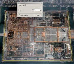
Ruler Tool
The ruler window floats and can be moved around. When the window is open, whatever location you click on in Google Earth begins the measurement and indicates a starting or ending point for the ruler.
Line
To measure in a straight line, click on the Line tab. Click one time on the beginning location (it creates a red point) and let up the mouse button. Click a second time of the ending location. You may need to use the keyboard controls so you can see the ending location (or start the process more zoomed out.) Once clicked, the line end points can be relocated by clicking and dragging on either end point (the end point turns green when being moved.) In the Ruler dialogue box, the distance will be displayed. The unit of measure can be set to miles, kilometers, feet, inches, etc.
Path
To measure a path, such as the route you travel to school each day or the perimeter of a building, use the Path tab. Similar to the Line tool, begin by clicking one time at the beginning location. Don't be concerned than no lines are showing yet. Click the next location in the path and a line will be displayed. Continue clicking along turns or corners in your path until you are finished. A cumulative distance is calculated as you click. If you mess up, just clear it and start again.
Polygon
The Add Polygon Tool is used to identify a shape or area. In the example below it is used to identify the shape of a pentagon. When first using the Polygon Tool it will seem like it's not working. This is because a shape must have at least three points to look like a shape rather than just a line. And the line between points is transparent and impossible to see. The key is to carefully click on each corner of the polygon shape. As you click the shape will fill in. You may need to move the shape window by the title bar if it is in the way. You can change the color and opacity so it's more transparent in the Style, Color tab. Use the path tool to measure.
Learning Activity: Comparison - Jet Pack vs. Driving
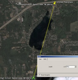
If you were provided with a jet pack as James Bond used in the movie Thunderball, you can now fly directly to school "as a crow flies" - in a straight line. How many miles shorter will your trip be now that you can travel by jet pack instead of by driving?
Tip:
It helps to have placemarks to identify the location of your school and your home. See the Placemarks section for tips on adding placemarks. Using the line tool to measure point-to-point is relatively easy. Record this distance. Recording the driving distance may be more of a challenge and take a few attempts. In Layers window turn on the Road layer and other layers you may need. To measure the driving distance from home to school, use the Ruler’s Path measurement tool. Click the starting location and click at each change of directionrs or corner. The corner points you create can be moved by clicking and dragging. A cumulative distance is calculated as you click. If you mess up, just clear it and start again. Record this driving distance. Does this distance seem correct?
Learning Activity: Calculate the Area of a Pentagon
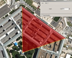
Find the area inside the Pentagon
Using the ruler's path tool to identify how the pentagon is made up of 5 equallaterial triangles. Calculate the area for one triangle and multiply this number by 5 to calculate the total area of the pentagon. The formula for calculating the area of a triangle is: area = 1/2 base * height. You may need to use the line tool for measuring height. Compare the answer you calculate with this pentagon area forumula from Yahoo Answers
to see if they are the same. Pentagon area = 1.72 * (length of a side)^2
Extension activity
Identify the pentagon by drawing a transparent pologon over the top of it. Enter this information into the polygon's window in Google Earth. The <BR> are HTML code for carriage returns:
How do you find the area of a regular pentagon?<BR>
http://www.math-prof.com/Geom/Geom_Ch_26.asp <BR><b>
Area = 1.72 * (length of a side)^2 </b><BR><BR>
If you wanted to derive this yourself so that you better understand where the formula came from, you could divide the pentagon into 5 equal triangles, then get the area for any one of the triangles, then multiply the area of the one triangle by 5 to get the area of the pentagon.<BR><BR>
From: http://answers.yahoo.com/question/index?qid=20061015163807AAJK2eq
Learning Activity: Estimation
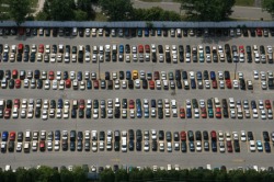
Visit Amusement Parks around the U.S. or world where there are high resolution images of the parking lots and having them estimate the number of: A. cars in the parking lot, B. Park attendance based on the average number of people per vehicle, etc.
Idea from: http://www.gelessons.com/cgi-bin/ideabucketread.cgi
Real World Math: Using Google Earth in the Math Curriculum
A rich collection of resources and lessons to teach and reinforce math concepts using Google Earth. Resources from the lessons section include: Concept lessons - uses Google Earth to present a concept such as rates or scientific notation; Project-Based Learning lessons require group collaboration and may take longer an d require some additional materials; Measurement lessons use the ruler tool for problem solving; and the Exploratory lessons explore topics such as fractals, topology, and modern geometry. http://www.realworldmath.org
Additional Resources
Curriculum Connections
What could students measure to better understand measurement concepts? Examples include: the distance from one shore to another, the distance down the Mississippi River, the length of the Great Wall of China. The polygon tool and the circle tool could be used to help student understand area or the blast diameter of an explosion. Consider how could the ruler help students to understand standard to metric conversations?
Michigan Content Expectations for Math
Grades K-8.pdf
High School.pdf
